Weekend Outing: White Hill and Jeppe Knave Grave
Having spent most of my recent weekends working away getting my new house in order, I managed to get out on a long overdue walk. In fact, I went on two walks, both fairly short. The first took me to the north east of the Forest of Bowland, where from the cross of greet I walked up White Hill, which is classified as a Marilyn. On the return journey back to Langho, I stopped at the car park on the nick of Pendle and visited "Jeppe Knave Grave."
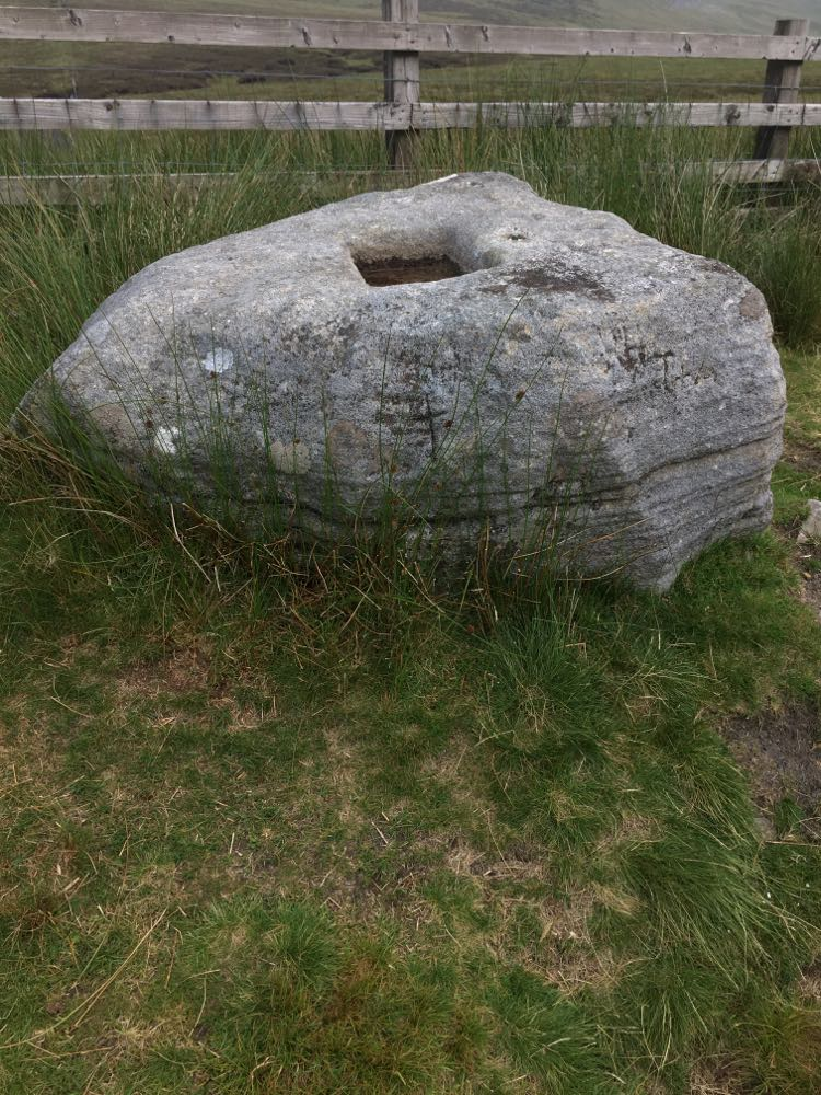
White Hill is 1785 feet. It lies to the east of the remote Wolf Hole Crag and to the south of the village of High Bentham just over the boarder in Yorkshire. There is a small parking area beside the cross of greet. The cross of greet, which used to form the boundary between Lancashire and Yorkshire is a sandstone slab with a fairly shallow, square shaped hole. As the name suggests, some believe the hole is a socket which previously held the foundations of a cross. But others are sceptical of this theory on the basis that the hole is quite shallow and would not have been able to carry a large cross. An alternative theory is that greet was a plague stone. These were used by people during the plague to wash money, in the hope of avoiding the black death.
I'm not sure which of these accounts is correct. The hole is undoubtedly shallow, though perhaps it was once deeper. Either way, greet is old. I couldn't find any precise information on its age. Though the cross is depicted on Saxton's map of 1577. Nowadays, the cross of greet is a popular challenge among cyclists given its high prominence at the apex of a picturesque road running through the Tatham fells in the forest of Bowland, which is often ascended from Slaidburn to the south or High Bentham to the north; the latter route passing the Great Stone of Fourstones, an 18 foot boulder with man-made steps allowing easy access to its top. Fourstones was depicted by Wainwright in his sketches of the forest of Bowland.
Cross of Greet:

The walk to the summit of White Hill from Greet is quite short. There is a sign indicating a right of way, which basically follows a fence boundary until you reach the trig point. The top is notable for a small, tower-like structure, surrounded by peat. The entrance to the structure is small. I am a small chap, but I had to crouch to get inside (which I did, as I enjoyed a Jet-boil lunch in an attempt to evade the howling wind). The structure is hollow and feeds out to the top. So what is it? Information on the structure is scarce. From what I can gather, it was a sighting tower used during the construction of the tunnel that carries water from Haweswater reservoir; this tunnel runs underneath White Hill. Haweswater was constructed in the 1930s, submerging the now lost village of Green Mardale in the Lake District. The tunnel carries water, for the most part underground, down to Manchester. There are some areas where the tunnel is exposed, including within the forest of Bowland, such as where it crosses the river Lune near the Crook O'Lune.
From the summit of White Hill there are views out to the wide expanse of the Forest of Bowland in the west toward Wolf Hole Crag and to the Tatham Fells in the east. There are also good views over to the Yorkshire Dales. There is also a small tarn on the top of the fell. From White Hill you can proceed to the much more remote Wolf Hole Crag. It is a fell I have been meaning to summit for some time. Though if you do decide to do it, give yourself ample time and come prepared for boggy terrain. Being quite some distance from any roads makes the ascent to Wolf Hole a long one.
Trig point, tarn and "tower" at the top:


******
After descending White Hill, I jumped back in my car and made my way to the Nick of Pendle. I was in search of Jeppe Knave Grave and the nearby trig point. I found the small collection of stones known as Jeppe Knave Grave (see the picture below).


It is hard to tell from the picture, but there is in fact an inscription on one of the stones, now so faded that it is barely readable. It marks the spot as Jeppe Knave Grave. According to local folk law, it marks the spot where a 14th century robber was buried. Whether there is any truth in this account is debatable. What is known, is that the spot was a burial cairn, likely from the Bronze Age.
Nearby trig point:

References:
https://thejournalofantiquities.com/category/jeppe-knaves-grave-at-sabden-in-lancashire/
https://www.megalithic.co.uk/article.php?sid=27360

Comments
Post a Comment