My Christmas Eve Walk (route included): A Circular Through Spennymoor Woods and back via Tudhoe Mill Nature Reserve
The Durham coalfields defined a way of
life for generations. Once a hub of industrial activity, the towering and
intimidating heavy machinery was visible for miles around. Not anymore. Mining
has, unquestionably, left its mark on the landscape. The scars are still visible to those who look. Many former railway lines which serviced the mines are now in use
as walking and cycling paths. Many towns and villages only came into existence
to house the miners and their families. But the mines themselves have all but
disappeared, save for those preserved as museums, such as Killhope; and those
which, though disused, have been left exposed to time.
This walk takes in several former Co Durham mines: Merrington Colliery (Spennymoor Pit), an old shaft in Burton Woods and Tudhoe Mill Drift Mine. Merrington Colliery has been replaced by Burton Woods housing estate, which is passed by at (2). The nearby shaft in Burton Woods (the actual wood), needs some finding. It is off the main track in the wood to the left of Burton Beck Farm-house. A few metres of the shaft’s stone work is clearly visible. It is cordoned off by the flimsiest of fences affixed to which is some broken signage with references to the Coal Authority and Balfour Beatty. This shaft is shown on the ordinance survey’s map (1888-1913), the link to which I provide below.
As with many former mines, Tudhoe Mill
Drift Mine is now a nature reserve maintained by the Wildlife Trust. It was
also, for a time, the workplace of the celebrated Spennymoor painter Norman
Cornish – though the mine Cornish is primarily associated with is the Dean and
Chapter Colliery in Ferryhill, where he spent most of his working life.
The last few times walked through Spennymoor woods I saw deer. From the river, kingfishers and cormorants are frequent visitors. On a recent visit, I had then pleasure of watching a weasel scurrying in and out of the gaps in the flood defences on the opposite side of the river. The highlight of this walk is the view from “Pebble Beach,” a spot which, though no longer pebbly, offers a fine views along the river wear (3). I was here on Christmas eve. The wear was rolling rapidly. The water level higher than usual. Looking out to the left you can see what’s left of the Page Bank village, once home to a thriving mining community, whose lives were built around Page Bank Colliery. Now, all that remains are a few farmhouses surrounded by fields. On the other side of the river there are large stone slabs, providing vital flood defences, behind which a small tree plantation. Out to the right, the river rolls by Croxdale woods before passing under the ancient Sunderland Bridge.
The Route
Difficulty: Moderate
Distance: Approx. 4 miles.
Terrain: Much of the walk is on gravel
paths. But the walk through the woods can be fairly boggy in places.
(1)
Start
at Whitworth road car park on the Auckland Way. Cross the road and take the
track going left, coming out at the Burton Woods housing estate. Cross the road
on the left and re-join the track. There is a choice here. The most
straightforward route is to continue along the track (if so, skip to (2)).
Alternatively, you can enter the woodland to the left, and take the little
detour described as follows:
Optional Detour to Mine Shaft: There is no
official public footpath on the map through the woods on the left of the track. But there are several reasonably warn
paths. And the large gaps in the hedgerow with nothing – not even a sign – to
deter people entering, suggest that no one is particularly bothered about
people going through here. And given the narrowness of the wood, you can’t go
far wrong by following the course of the beck. It is interesting to explore
these woods. They formerly hosted mine shafts, the remnants of at least one of
which can be seen today. It can be found in the woods directly parallel to Burton Woods
farm. This can be accessed in several ways. Following the beck, there is a little
tunnel under a bridge which passes under a gap in the woods alongside a horse’s meadow.
The mine shaft is basically just after the small gap in the woods, and you can
get to the other side either by crossing the fence, or, if the beck is dry,
underneath the tunnel. If you feel uncomfortable taking this route, you could
get back on the main track, and enter the woodland at the bend at the bottom of the track, and then follow the woods in the opposite direction. The mine shaft is mentioned in the old Spennymoor map, but I could not find
any information online as to its exact age.


(2)
Continuing
along the track, you pass Burton Beck Farm on your right, with its old
fashioned looking barn on the left. The track then leads to a junction. We are
taking the left hand route, following the Camino de Santiago waymarker, albeit
briefly. It is at this point, as you cross Burton beck that this route and the
one mentioned in the italicised paragraph re-join. Take the path immediately on
the right leading into the woodland. It is fairly straightforward from here to
reach the river. Continue along this path which follows closely by the farmer’s
field. The path then intersects with the path from black plantation coming from
the right. You could turn left here or continue forward on the path you are on.
Both paths join up further down the line anyway. Things can get fairly boggy
from here on in. The surface of the path is scared and uneven in places. As you get
closer to the river, the view opens out across the fields to the left, over to Woodhouse
farm and Page Bank. On the right, the beck is now some way below the path. The
path follows close to the fence before emerging at the river Wear, with a
bridge on the right which crosses Burton Beck.

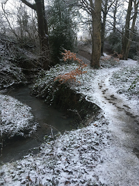
(3)
We
will eventually go over the bridge to the right. But before doing so, it is
worth a detour to “pebble beach,” a fine spot with a nice view of the river,
ideal for a hot drink or lunch. For those unfamiliar with this spot, it can be
awkward to find, especially during the summer months when it is largely
overgrown. To get there, take a left turn onto a faint path along side the
fence boundary. After about a minute or so, veer off right toward the river.
The term “pebble beach” now seems like a misnomer; the rising waters now cover
the pebbles leaving only the grassy riverbed exposed. But an ideal spot
nevertheless to stop and admire the wear.

(4) Having finished at pebble beach, return to the bridge over the beck. You will notice a memorial on the side of the bridge. It has been here many years and is still tended to. When I was here on Christmas Eve, it was marked by a festive wreath. Cross the bridge then take a right turn following the beck away from the river and toward Tudhoe. When I was last here, I spotted a deer rummaging around the trees. The path emerges at the entrance to Tudhoe sewerage site. There are two right turns in quick succession, which emerge at the same spot. Take the second one over a low metal gate if you want to see the Wildlife Trust’s Tudhoe Mill Wood information board. This is now a nature reserve. It used to be a drift mine and for a time, was the workplace of Norman Cornish.
(5) From here you
follow the Camino de Santiago trail (the waymarker with a yellow star and a
dark blue background). At the junction near the information board follow the
well-trodden path to the right – there is a faint path to the extreme right
which you should ignore. This shortly takes you across Valley Burn beck via
what is best described as a big slab of a bridge. Continue on, ignoring the
path which veers out to the right. Eventually you emerge behind a housing
estate. The track passes an information board – one which has sadly been defaced, entitled Black Plantation, which contains details of some of the area’s
former mines. Continue past the information board along the track. At the end of
the track take the left turn at the bend to retrace your steps back past Burton
Woods farm to the car park at Whitworth Road.


Comments
Post a Comment